
Oslo, Norway
The Deep Cities NIKU team developed the Deep Cities Theory Tool testing in particular an assemblage methodological approach through three Norwegian urban regeneration case studies where heritage partake in urban placemaking.
The three case studies are the Tukthus wall (what is left of an 19th century old prison), the Vulkan neighbourhood (an 19th century industrial working area) and Sørengkaia (an 19th century industrial harbour area) in Oslo, Norway.
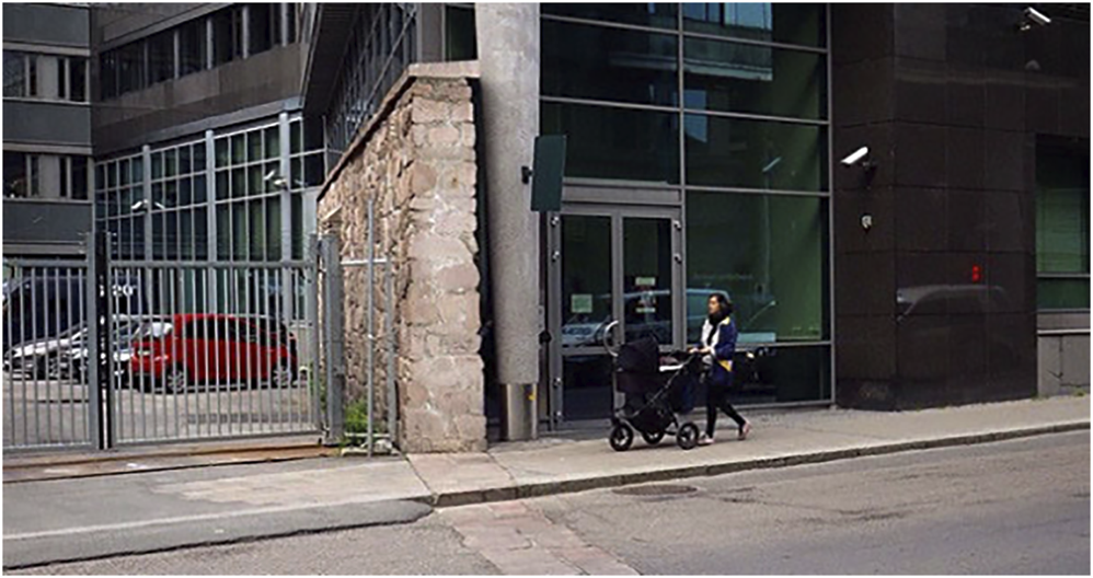 Tukthuset ruin wall. © Torgrim Sneve Guttormsen, NIKU
Tukthus quarter
Location

Understanding the site
The historic Tukthus quarter [Tukthuskvartalet] from the eighteenth century was a prison taking up a whole quarter in central Oslo built on two floors with a church in the centre. The history of the place as a prison witnesses a dark heritage, which is associated with a difficult, shameful, and painful past.
This negative history was perhaps one of the reasons why people did not oppose the demolition of the buildings, which was announced publicly in the media in 1938. During the 1930s, the property was gradually separated, and the buildings were demolished. Only parts of the prison walls remained, which, with its ruin-like appearance, yielded an anecdotal storytelling materiality. In 2000, a new urban plan with the new buildings were completed, with the restored ruined wall of the prison integrated as part of a new restaurant and traces in the asphalt crossing the local street. It continued through a large new office building complex containing a police station and more restaurants.
Heritage has become purified and transgressed, partaking in the contemporary life of the area’s vibrant nightlife, where heritage is used anecdotally, staged and branded to create a good atmosphere for consumers socialising in nearby cafés and squares. The planning process of the Tukthus quarter has largely been an expert-driven ‘formal’ and ‘authorised’ process, where the discussions and disputes have been between urban planners, architects and heritage managers.
Tools and methods applied
The methods used are carried out as three interconnected steps. First, we conducted a document and media analysis of the historical process to reveal the heritage values of what is preserved today. Second, we carried out a street-intercept survey, conducted with people we met in the case study area. We asked about their opinion about the urban environment and the cultural heritage of the site, their reaction to the aftermath of urban transformation, and how they perceive and interpret the ruins of this specific fragmented heritage today. The respondents were passers-by encountered in Calmeyers gate, and visitors at the Latin-American restaurant ‘Tukthuset Mat & Drikke’ and the cultural café/bar ‘Kulturhuset’. The data were completed with surveys with the staff from the cultural café/bar ‘Kulturhuset’ and the police station, and two additional short face-to-face individual interviews. Finally, we also carried out on-site observations prior to and throughout the interview process in order to explore the area and vicinities, and for observing people’s comportment around the ruins. The purpose of the questionnaire is to investigate people’s own perceptions and interpretations of the site and of the management of Tukthus’ ruins over time.
66 individuals were approached in the street-intercept survey. A total of 44 individuals (23 women and 21 men) responded to the survey. 41 questionnaires were completed, and 2 short interviews were conducted. 35 questionnaires were completed on site (16 at the restaurant, 19 at the cultural café/bar) and 6 more were mailed back (in a pre-stamped envelope). Among the 44 respondents, two individuals responded as a couple (1 questionnaire).
Key findings
The sample exhibits three major characteristics. First, it gathers data on typical members of the population using the case area, which means that the results are representative of people’s meanings and experience of the case area. Second, half of the participants were familiar with the area and a quarter of them lived close by, which suggests that they have geographical insights and some historical knowledge. 52% of the participants said they are often in the area (to attend work and cultural activities, or visit restaurants and cafés), and 41% said they rarely visit the area (occasional stop for food, city walk, shopping or shortcut on the way to other places). 7% were visiting for the first time. Comparatively, 23% wrote that they lived in the urban core of Oslo, and 48% wrote that they lived in other areas of Oslo. 29% wrote that they did not live in Oslo.
The quality of the architecture and public space seems contested. 25% seemed positive towards the urban development. They were satisfied with the latest architectural developments (6) which, according to 2 informants, creates “a very modern and solid impression”. They explain that it is important to preserve the cultural heritage, but not at the expense of everything else. 13 informants said it is not a good area and specified that the public space was “chaotic” (4), “fragmented” (1), “cramped” (1) or “noisy” (2), with “little dedicated outdoor space” (2). Some even used the words “ugly” and “not beautiful” (4), 2 informants explained that the architecture was “uncreative” and “uninspiring”, showed “poor urban planning” and that it looked aesthetically odd with parts of Tukthus wall protruding out a modern facade. Informants who thought the wall was nicely presented in the restaurant (5 in the survey, and most of the restaurant’s customers directly to us) and the police station (1), added that ruins are an attractive feature in urban development.
Informants who made historical connections with the area (8) said they appreciated its authenticity. Nonetheless, the informants’ majority were unaware of the presence of ruins, and even fewer knew that they are the remnants of a bigger complex. For example, only 3 informants knew about the churchyard and the graves that were uncovered during excavation work at the site in 1989. One informant also doubted that many citizens knew that there once was a women's prison (just 9 out of 44 informants associated Tukthus to a women's penitentiary).
Heritage and planning implications
The case study demonstrates that there is a need to disseminate historic knowledge in order to let people learn about their not-so-distant past.
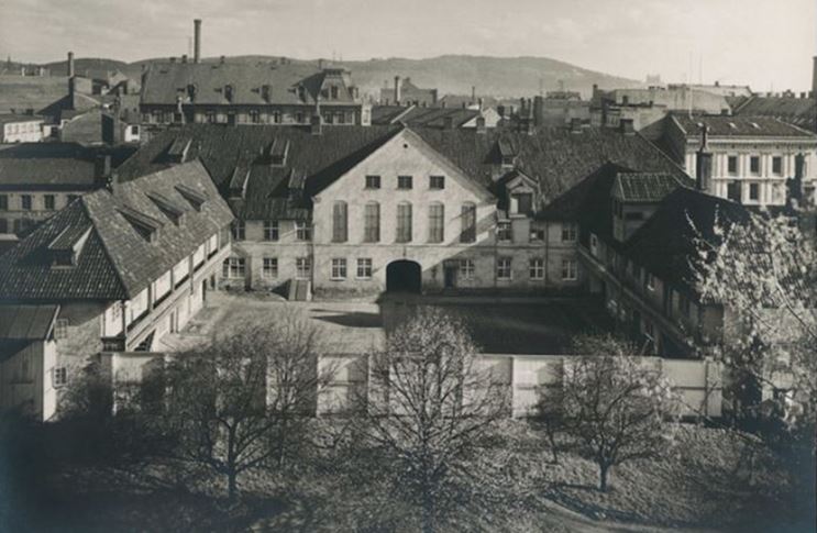
 Vulkan © Finn Ståle Felberg/Aspelin Ramm
Vulkan
Location
Vulkan is an industrial complex located on the southwest border of Grünerløkka.
Understanding the site
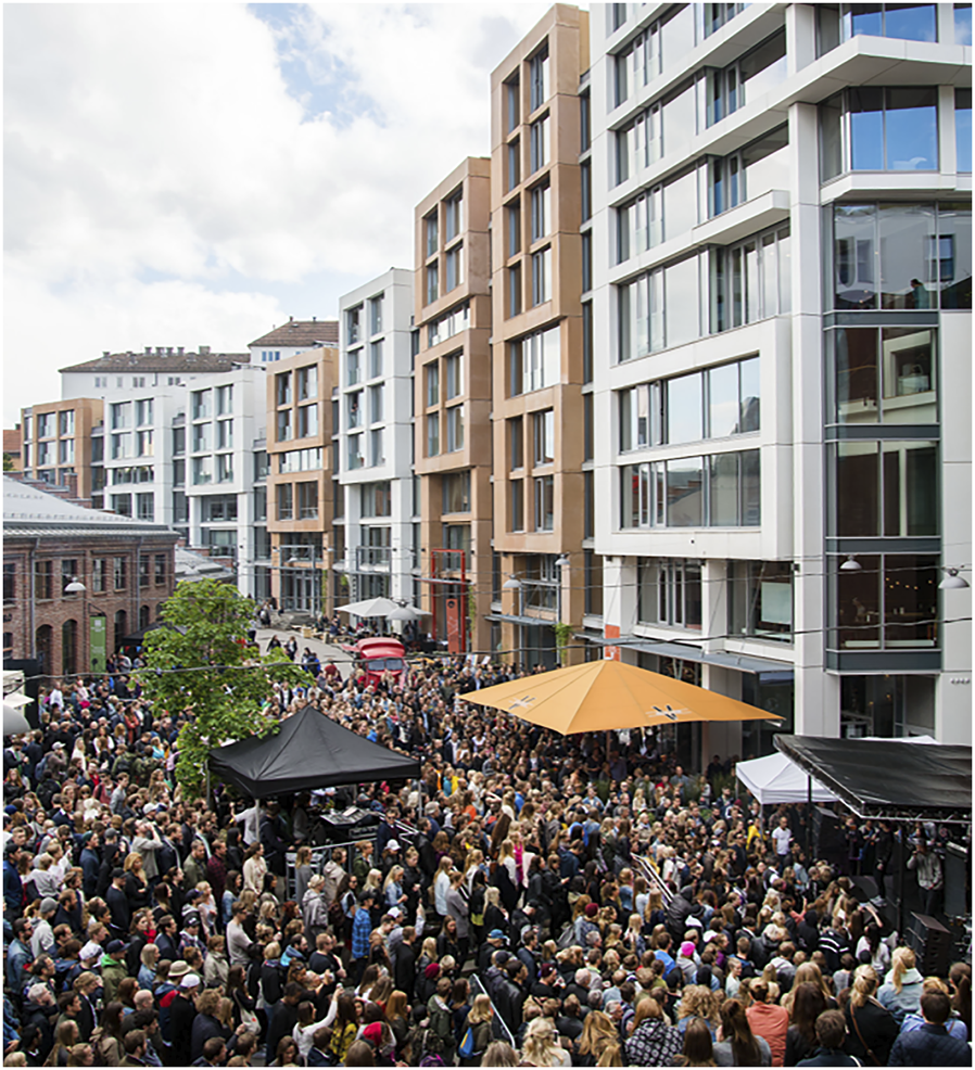
Vulkan is one of the first industrial neighbourhoods in Oslo. The neighbourhood has been subjected to redevelopment and revitalisation. Vulkan was initially an iron foundry in 1873, located by the Aker River. From 1968 to 1999, the area was a rental for mixed industrial uses, and during the 2000s, it underwent several regeneration projects. Today, the site includes several public areas and pedestrian pathways that benefit from a view of the river. Two historical industrial structures host an indoor food market and a national stage for dance. The remaining surroundings provide spaces for recreation, businesses, housing, parking, sports and educational institutions. The users of the site include local dwellers, students and people visiting different establishments, such as a hotel, restaurants and bars, a supermarket and a health centre for women. From being a remote and little-visited area, Vulkan has become a distinct and colourful district in the city..
Tools and methods applied
We have carried out on-site observations, document studies and interviews with stakeholders and developers involved at Vulkan.
Heritage and planning implications
The redevelopment plan for Vulkan demonstrated participatory processes involving culture, higher education and municipal authorities, including the heritage sector. Private entrepreneurs, state and municipal agencies and, to some extent, NGOs played a central role at the early planning stage. An inclusive planning process was developed with heritage expertise to frame heritage attributes and values in the service of broader societal interests. Studies in the area have demonstrated that the dialogue between heritage managers and the food market expressed a win-win situation, resulting in both parties fulfilling most of their expectations.
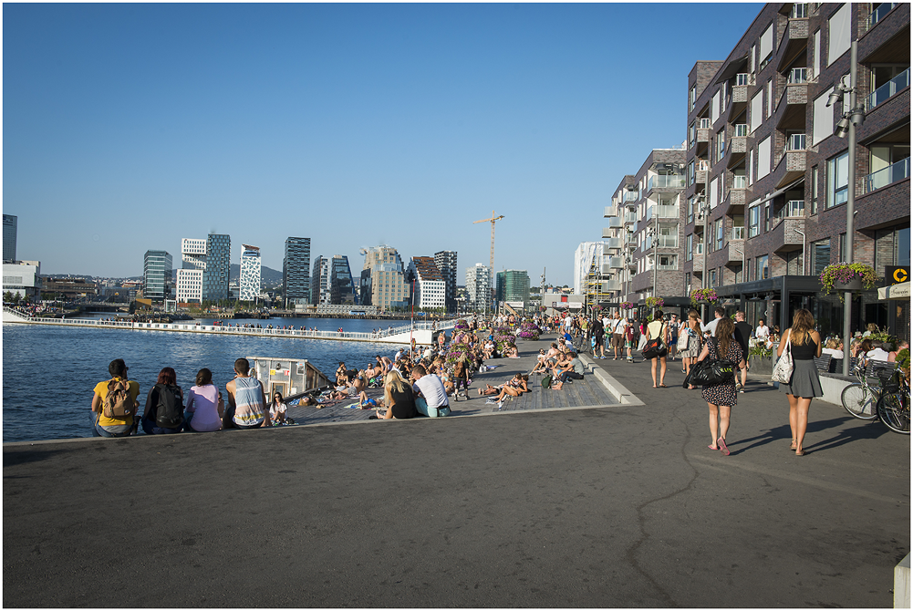 Sørengkaia © Katrine Lunke, Creative Commons Attribution-Share Alike 4.0 International licence
Sørenga
Location
Understanding the site
Sørenga is a comprehensive urban ‘waterfront’ development scheme, involving different stakeholders, such as architects, private developers, politicians and residents. The uses of culture, including heritage, were discussed in terms of generating capital and tourism, although this approach received criticism for being superficial and not really interested in culture per se, apart from its economic potential. One area that has been recently developed in Bjørvika is Sørengkaia, which contained a vibrant harbour area in the nineteenth century. Sørengkaia was then filled with cranes and ship containers, until it was transformed or ‘reassembled’ into a new residential area in around 2010, including cafés, restaurants and a large public outdoor pool at the southern end of the peninsula. In terms of heritage, there are almost no remaining physical structures at Sørengkaia, apart from some moorings and wooden quay structures. The heritage dimension is primarily represented semiotically in black and white pictures and textual signposts. This is done to inform citizens and potential buyers of apartments that they are on historic ground. Heritage is, in other words, used to market the area by the developers. In several of the entrance halls of the private apartments, there are images of old buildings on the walls. One example is a photograph of an industrial structure that has been ‘resemiotised’ from a tangible red brick building into a timeless, two-dimensional photography.
Tools and methods applied
We have carried out on-site observations, document studies and interviews with stakeholders and developers involved with a relation to Sørenga, whether they are residents or planners.
Heritage and planning implications
If tangible heritage is removed, it Is still possible to disseminate heritage values by mean of semiotic visualisations, for example in the form of artworks or signposts.
Further Readings:
Torgrim Sneve Guttormsen, Joar Skrede, Paloma Guzman, Kalliopi Fouseki, Chiara Bonacchi, Ana Pastor Pérez, 2023, Assemblage urbanism: the role of heritage in urban placemaking, Journal of Cultural Heritage Management and Sustainable Development, https://www.emerald.com/insight/content/doi/10.1108/JCHMSD-12-2022-0208/full/html
Torgrim Sneve Guttormsena, Véronique Karine Simon Nielsenb and Joar Skredec (forthcoming), Fragmented heritage: Valuing urban ruins from an expert versus people-centred approach, IJHS.
Last update
12.02.2024