
Architectural Level - Stratigraphic Building Archaeology
The goal of Stratigraphic Building Archaeology is to determine the construction phases of the buildings (analyzing signs of transformation, restoration, reconstruction, and demolition) within a relative chronology and, subsequently, their settings in an absolute chronology introducing dates or periods.
1) Identify the building
Find in detail the building you want to study on available maps (at least on Google maps).
2) Collect historical data, photos and documents regarding the building
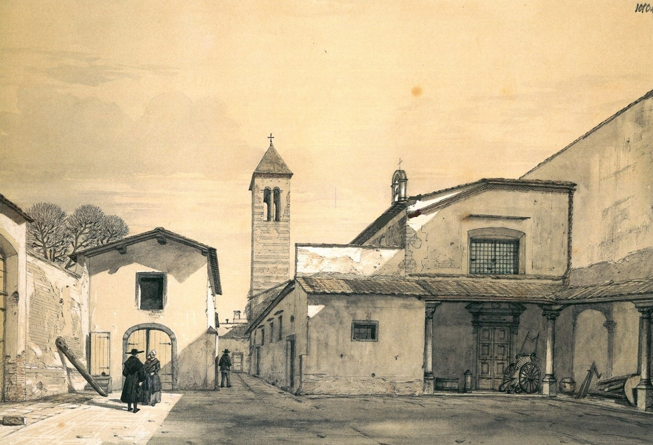
Locate the chosen building on historical maps, on historical photos, on other archival documents, and on published papers or books.
3) Elaborate a first historical overview of the material transformations of the building
Considering the collected data, elaborate an historical synthesis of the key transformations of the building over the centuries to use as outline later in the Light Archaeology analisys.
4) Instruments needed
Below are some objects that will serve, along with other more specific elements, the subsequent activities of Light Archaeology
- Pencils, pens (of different colours), glossy paper and graph paper
- Paper notebook
- Mobile camera or (more preferable) reflex camera (with basic auto lens 18-55 mm)
Now we illustrate the 4 fundamental steps of the Stratigraphic Building Archaeology workflow.
STEP 1
Identification of the building and the stratigraphic visibility
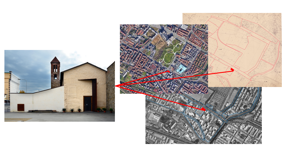
The first step of Stratigraphic Building Archeology is to topographically identify a building in its urban context. Quickly passing by the general architectural complex and the different buildings in which it can be divided, we can identify the different particular elevations (external or internal) which have stratigraphic visibility and can, therefore, be analyzed. As a second step, we proceed with a photographic campaign to provide accurate documentation of the state of the overall stratigraphic visibility.
For example, in the case of Novoli in Florence (Italy), San Donato was initially identified as an architectural complex (fig. 1) and, subsequently, the three buildings from which it consists were defined (fig. 2): the church of San Donato, the bell tower, and the vicarage. Focusing on the church of San Donato, the internal and external elevations (fig. 3) were identified and defined and external E1 (the current façade of the church) and internal E13 were chosen due to their stratigraphic visibility (figg. 4-5).
STEP 2
Photogrammetric survey and digital model of the masonries
After choosing the elevations, the next step is the photogrammetric survey. Through a photographic session covering entirely the selected elevations, we modeled photographic photoplanes. These last were then used to report and to map the different stratigraphic units identified in the elevations of the buildings.
We follow the above-described workflow also in the case-study of San Donato church: E1 and E13 elevations were documented through photographic and photogrammetric surveys and then digitized using photographing modeling softwares (figg. 6-7).
STEP 3
Identification and analysis of stratigraphic units
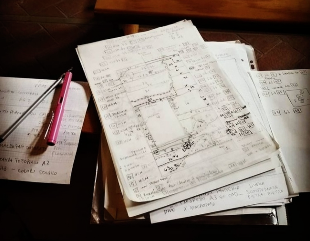
Step 3 of the analysis is the identification, definition and mapping of different stratigraphic units in the masonries. These last are intended as constructive or destructive actions with temporal autonomy. There are two different types of stratigraphic units: positive (if they result from a single constructive action) or negative (if they result from a removal action) (fig. 8). This phase is usually carried in the field.
In this phase the analysis consists in looking for physical relationships between adjacent archaeological units and processing the temporal stratigraphic sequences (posteriority, anteriority, contemporaneity), by organizing all the stratigraphic units in temporal order. A number is assigned to each stratigraphic unit (negative unit numbers are usually underlined to immediately distinguish them graphically). The limits of archaeological units and their relationships are reported directly on a paper sketch and then digitized and vectorized on the digital photographic photoplanes (see Step 2).
The physical relationships between the different archaeological units can be positive (leans on, covers and tied to) or negative (cuts). Some units are then defined as covering units if they cover other units, such as plasters, paints, wall coverings, and flooring. Every limit and relationship are also graphically represented in a sketch and then in the vectorization by standard symbols (figg. 9-13). In the same vectorization, as in the analysis of E1 and E13 of San Donato church in Florence, is foreseen the stone-by-stone design of the masonries of the elevation under analysis (fig. 15).
STEP 4
Harris Matrix diagram and the historical phasing of buildings
Starting from the recording sheet (see Step 3), the identified and mapped stratigraphical units are organized using Harris Matrix diagram, a system of representation of the stratigraphic relationships that reports the chronological sequence (from the bottom-past to the upper part-present) of all constructive and destructive actions identifiable on masonries buildings (fig. 16). Considering the analysis of different archaeological units, as final result of the entire described process, the archaeological units are organized in the Harris Matrix diagram into different historical phases aimed to represent the history of the buildings. Considering the case-study of the church of San Donato in Florence, and analyzing the E1 (the façade) and the interior E13, assigning to every historical phase a specific number and colour, it was possible to represent the various phase of the building between the 12th and the 20th century (figg. 17-18).
Last update
09.01.2023